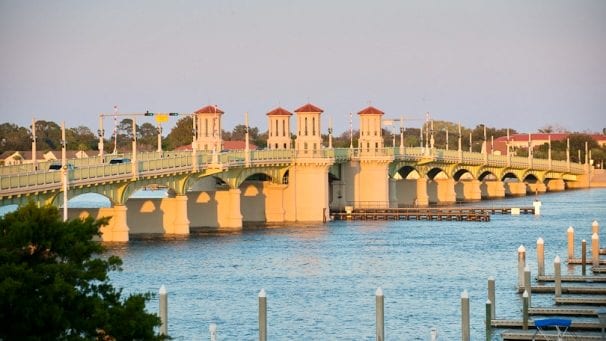
The Bridge of Lions is one of those St. Augustine landmarks that invites a photograph before you know much about it. Its low sweep across the water, repeating arches, and red-roofed towers make it a distinctive part of the bayfront. The sculptures that gave the crossing its name are part of that story, even while they are temporarily away from their familiar posts.
Visitor update, checked September 25, 2026: The two original marble lions at the western, downtown entrance were removed in January 2026 for protection and restoration during the seawall improvement project. They are not currently available to view at the bridge. Waterfront construction may affect pedestrian access; follow posted closures and detours. [4, 5]
The lions behind the name
The original western pair are Fiel, meaning “Faithful,” and Firme, meaning “Firm.” Added in 1927, the Carrara marble sculptures were modeled after the Medici lions in Florence, Italy. They were a gift from local physician and benefactor Dr. Andrew Anderson. Their usual position is on the historic downtown side of the crossing. [6]
For generations, the pair has helped give this working road crossing the appearance of a ceremonial entrance. Florida's transportation department identifies the western lions as the source of the bridge's familiar name. [1]
Their absence is temporary. The city arranged for them to be moved to a secure facility, where they could be protected and restored during the waterfront work. Visitors should not plan a close-up photograph of the original pair until their return has been announced. [4]
When will the lions return?
The city says the statues will return when the project concludes. Its June 2026 construction notice estimates completion of the $19.9 million seawall project in fall 2027, subject to weather and unforeseen circumstances. Earlier January reporting cited December 2028 at the earliest for the lions' return. These are differing published estimates, not a confirmed return window. Check for an explicit city announcement before planning a visit around seeing the statues. [4, 5, 7]
A new landmark for an old city
The bridge was completed in 1927, connecting downtown St. Augustine with Anastasia Island. Its construction belonged to a period of ambitious tourism and development, including Davis Shores across the bay. The design by the J. E. Greiner firm gave the city both a transportation link and a conspicuous waterfront landmark. [1]
The bridge also has a quieter history beneath its familiar outline. In a recollection published by the St. Augustine Historical Society, longtime resident James Augustine Ponce described the earlier wooden bridge and the rattling sound it made under passing traffic. He remembered the announcement of the new bridge, debate over its cost, and attending the ceremony when its lights were first turned on. [2]
That personal account adds a human scale to the view. The bridge that feels like an established part of St. Augustine today was once a much-discussed change to the waterfront. Ponce's description is a resident's later recollection, rather than a contemporary construction record.
Look beyond the photograph
If you are visiting the Castillo de San Marcos, the bridge is a natural landmark to include in your exploration of the bayfront. It lies south of the fort, near the Plaza de la Constitución. During construction, use open public sidewalks and marked crossings, and follow pedestrian detours rather than assuming the waterfront promenade is continuous. [5]
The bridge's historic appearance has required substantial preservation work. A major rehabilitation retained and repaired important architectural features while strengthening the structure; it reopened to traffic in March 2010. [1, 3]
Where public access permits, take time to notice the bridge's towers, repeating arches, and relationship to the city around it. Knowing why the lions are absent adds another chapter to the view: preserving a familiar landmark sometimes means protecting its most recognizable details somewhere else for a while.
Keep exploring with SAHP
A photograph captures the view. Knowing the story changes what you notice. Download the free St. Augustine History Project app to explore historic places and walking guides, and discover more of the city beyond its best-known landmarks. Start with the bridge, then keep exploring St. Augustine one story at a time.
During the seawall work, follow current city notices and posted signs. Historical descriptions and walking routes may not reflect temporary closures.